|
The historical context
The
Army Forces involved in the WWII were for the most brought
to define and to use specific geographical coordinate systems
in order to specify the localization of points or targets located
on the theater of operations. The fights of the First World
War had shown all the interest of such systems which, used in conjunction
with adequate cartographic data, had largely contributed to the
improvement of the action of the units of artillery on the battle
field. Considerations relating to artillery had precisely led the
French Army to adopt in 1915 the Lambert map projection "Nord
de Guerre", covering the North-East of France and Germany,
and which was going to be supplemented during the inter-war period
by the Lambert 1, Lambert 2 and Lambert 3 projections in order to
cover the rest of the French territory.
In
1919, Great Britain adopted on its territory the "British
System", based on a Cassini projection and on the use of
a reference grid. This system was superseded in 1927 by the "Modified
British System", more adapted to the coverage of large
areas and to a military operational use by terrestrial and aerial
forces.
|
|
|
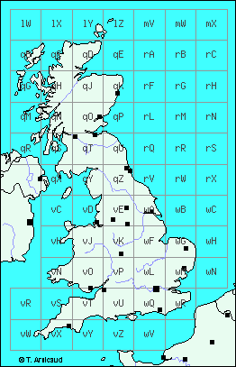
Diagram
of the grid used over the British territory ("Modified
British System")
|
This
"Modified British System" was going to be used during
the World War II by the British and American Armies, while being
extended to the European, North African, Middle East and South-East
Asian theatres of operations.
Characteristics of the "Modified British System" used
during the WWII
The
"Modified British System" used during the World
War II is based on the Cassini projection covering the British
territory, and on a series of other projections intended to cover,
while being put side to side, the whole of the theatres of operations.
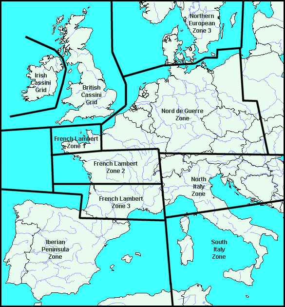
Western
Europe is thus cut out in ten zones, whose cartographic statements
have been produced at the end of the Thirties and at the beginning
of the war by the British and French Army Geographical Services
(War Office, Geographical Section, General Staff for Great Britain).
In
the "Modified British System", each projected area
is divided into squares of 500 kilometers side, each of which designated
by a letter. Each of these squares is subdivided into 25 squares
of 100 kilometers side which are also lettered from "A"
to "Z" omitting the letter "I".
These
squares of 100 kilometers side, which play a fundamental role
in the determination of the coordinates, and are thus often represented
on the maps of the time, are referred in a complete way by the combination
of two letters, for example 'vZ', indicating here the 100
km square Z included in the 500 km square v.
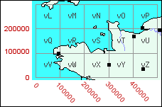
|
|
|
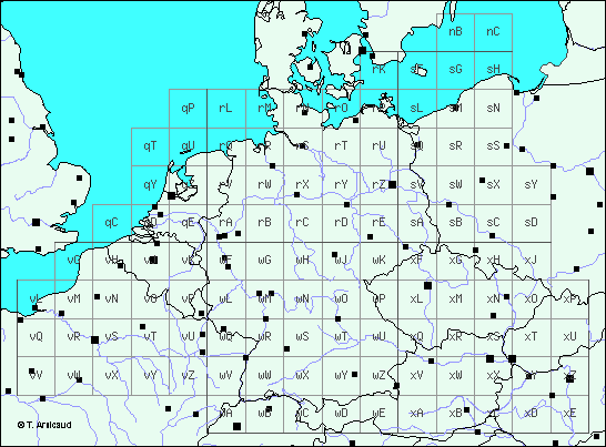
Diagram
of the grid used for the "Nord de Guerre Zone"
in the "Modified British System"
|
The
determination of the coordinates of a point in the "Modified
British System" is carried out in two stages : firstly by indicating
the reference of the 100 km side square inside whose this
point is located, secondly by defining the exact position of
the point inside this square.
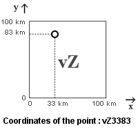
A point
is always located inside a square of 100 km by its co-ordinates
x/y respectively measured on its x-axis (West-east) and
y-axis (North-South), refered to the point of origin of this
square (left lower corner). According to the scale of the map used
for their determination, these coordinates are expressed in kilometers
or hundreds of meters ; a network of vertical and horizontal
lines separated by 10 km or 1 km is sometimes represented on the
maps in order to facilitate the reading of the x and y values.
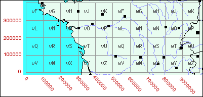
As
an example, the town of Alençon (France) is located
in the "vZ" square of the "French Lambert Zone 1"
(LZ1). When we determine the position of the city compared to the
origin of this square, using a map scaled to 1/250000°, we respectively
measure x=33 km and y=83 km. Formatting this result in the "Modified
British System", we finally obtain the following reference
: (LZ1) vZ 331/835 or (LZ1) vZ3383, by joining the two values.
|
|
|
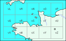
"French
Lambert Zone 1" Grid
|
|
|
|
As
an other example, the Strasbourg-Entzheim airfield (France)
is located in the "wV" square of the "Nord de Guerre
Zone" (NGZ). Its position, compared to the origin of this square
using a map scaled to 1/50000°, is given by the values: x=93000
m and y=93700 m. By expressing these measurements in hundreds of
meters, we obtain x=930 and y=937, which gives, in the "Modified
British System" format, the following coordinates: (NGZ)
wV930937.
|
The
absolute and "canonical" reference of a point
on the theatre of operations is thus defined by the combination
of three data, which are:
-
the name of the map projection or geographical area used
for the determination of the position (example: "Scandinavian
Zone 3")
-
the complete reference of the 100 km side square containing
the point (example: "vR")
-
the numerical data indicating the position of the point
inside the square (four or six digits according to
the precision of the determination).
Example
: Nord de Guerre Zone (NGZ) / rW705951
|
In
practice, the soldiers brought to use this system in operational
situations often used a slightly different way of writing the coordinates,
including the reference to the maps used for the determination.
Several
examples of references, corresponding to the same point located
in the area of Boulogne (northern of France), are thus given below:
- 1/
Reference EUROPE (Air) 1/500000 Sheet "STRAIT OF DOVER"
/ Map Reference vG7461
- 2/ Reference GSGS 3982 (1/250000) Sheet "BOULOGNE" /
Map Reference vG7461
- 3/ Reference FRANCE (Army / Air) (1/250000) Sheet 1 / Map Reference
G7461
- 4/ Reference GSGS 4336 (1/100000) Sheet 5 / Map Reference G7461
- 5/ Reference FRANCE AND BELGIUM (1/50000) Sheet 38 / Map Reference
744616
- 6/ Reference FRANCE (1/250000) Sheet 38 SW / Map Reference 744616
The
informations given by these references are only fragmentary if we
try today to locate the point without the original maps in hand.
In the case of the reference #3 for example, the only exploitable
data are the followings:
- the
point is located in the North of France
- the point is located into a (?)G 100 km side square
- the numerical data relating to the position of the point in the
square are: 7461
It
appears here fortunately that these informations, although fragmentary,
are sufficient to be able to go up with the complete coordinates
of that point. By consulting the grids used on the European Theatre
of Operations, we note indeed that the "Nord de Guerre Zone"
includes a square designated by the reference "vG". We
can deduce from it that the "canonical" coordinates of
the point are as follows:
Nord
de Guerre Zone (NGZ) / vG7461
The
researchers dealing with fragmentary coordinates will therefore
always have interest to take a look to the grids
used on the European Theatre of Operations, by using at
their maximum the contextual information which they will have been
able to collect otherwise (example: operations carried out in the
north of France, in the area of Strasbourg, etc…).
The conversion towards other systems of coordinates
The
"Modified British System" of coordinates is based,
as we saw, on the use of a series of map projections intended to
cover the totality of the Western and Central European territories.
These
map projections correspond, for some, to the "national projections"
used before the war by the involved countries, as Great Britain
("Cassini Grid") and France (Lambert 1, 2, 3 and
"Nord de Guerre"). The
coverage of the other geographical areas had to be ensured at the
end of the Thirties and at the beginning of the war using completely
new projections, like for example for the Italian and
Iberian peninsulas.
In
the case of already existing projections, the definition of the
grids was very simple, as we are going to see it here through the
example of the French Lambert zones, representative of the process
followed for the other projections.
As
we've seen it above, the Geographical Service of the French Army
used five geographical projections in 1939, corresponding to five
large areas cutting out its territory:
- the
"Nord de Guerre" zone, covering the North-eastern
part of France (as well as Belgium and Germany),
- the "Lambert 1" zone, covering the north-western
part of France,
- the "Lambert 2", zone covering the central part
of France,
- the "Lambert 3", zone covering the southern part
of France,
- the "Lambert 4", zone covering Corsica.
(it
should be noted that the Lambert 1, 2, 3 and 4 projections are always
used in France nowadays, a modification of the formulas of computation
having however been brought in 1948).
The
coordinate systems used for these map projections locate the points
using two coordinates, X and Y, expressed in meters. For example,
the co-ordinates of the center of the town of Alençon, measured
on a "Lambert 1" map of the time, are: X=433300 m and
Y=83500 m.
"French
Lambert Zone 1" Grid
"
French Lambert Zone 2" Grid
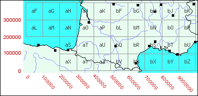
"
French Lambert Zone 3" Grid
|
The
use of these grids for a coordinates conversion from "Modified
British System" to "French Lambert System"
is shown throuh the following example:
The
"Modified British" coordinates of the Rennes-Saint-Jacques
airfield are :
(LZ1) VX962494
1/
we measure the co-ordinates of the origin (left lower corner)
of the "vX" square of the "French Lambert zone
1" (LZ1) grid :
These
coordinates are : X0=200000 m et Y0=0 m.
2/
the Lambert 1 (X,Y) coordinates of the airfield are computed
as follows :
X=
X0 + (962x100) = 200000 + (962x100) = 296200 m
Y= Y0 + (494x100) = 0 + (494x100) = 49400 m
|
The French Lambert 1, 2 and 3 system still being used in
France nowadays, it is quite easy to locate a point whose coordinates
are expressed in the old "Modified British System", by
reproducing the calculation above and consulting an adequate map
produced by the IGN (French National Geographical Agency).
On
the other hand, the "Nord de Guerre", "British
Cassini", "North Italy", "South
Italy"... projections not being used anymore, it is necessary
to do the conversion of the coordinates toward other systems, more
adapted to the localization of points on a modern map.
The
"Coordinates Translator"
proposed on this web site was developed for this reason : on the
basis of complete coordinates expressed in the "Modified British
System", it makes it possible to obtain the corresponding geographical
co-ordinates expressed in terms of latitude and longitude.
These co-ordinates can then be exploited quite easily using detailed
geographical maps or numerical atlases like the one proposed on the
MapQuest web site.
|